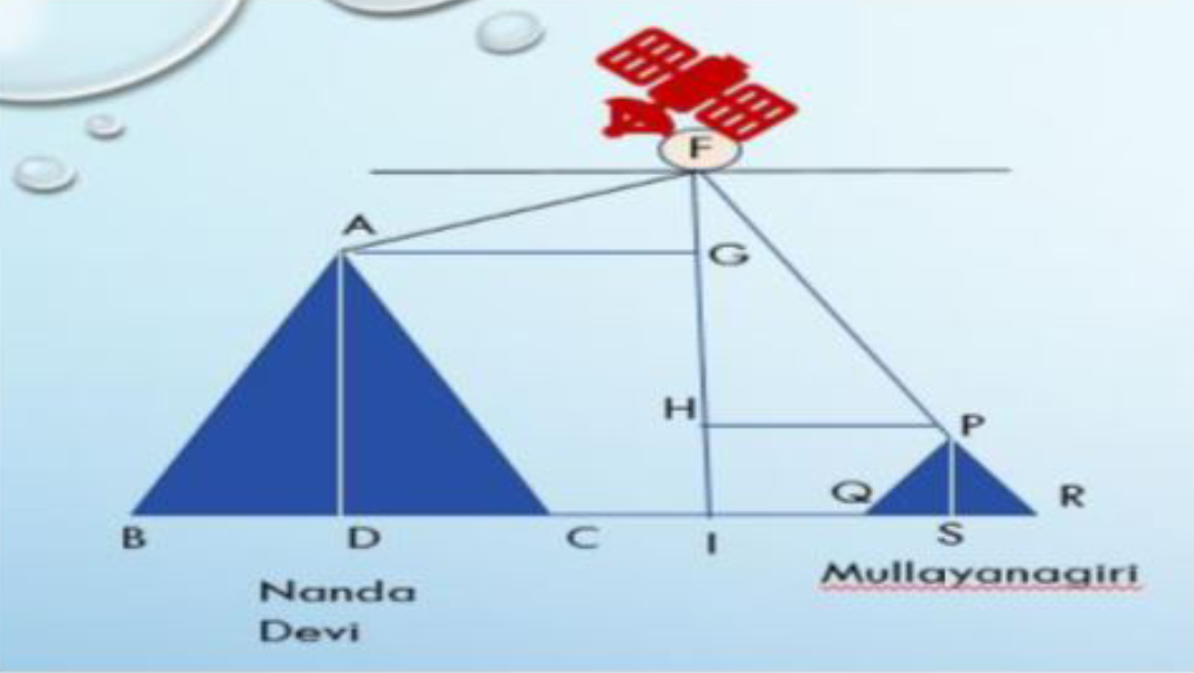
A Satellite flying at height h is watching the top of the two tallest mountains in Uttarakhand and Karnataka ,them being Nanda Devi(height 7,816m) and Mullayanagiri (height 1,930 m). The angles of depression from the satellite , to the top of Nanda Devi and Mullayanagiri are 30∘and 60∘respectively. If the distance between the peaks of two mountains is 1937 km , and the satellite is vertically above the midpoint of the distance between the two mountains.

The distance of the satellite from the top of Mullayanagiri is
1139.4 km
577.52 km
1937 km
1025.36 km
The correct Answer is:C
Step by step video & image solution for A Satellite flying at height h is watching the top of the two tallest mountains in Uttarakhand and Karnataka ,them being Nanda Devi(height 7,816m) and Mullayanagiri (height 1,930 m). The angles of depression from the satellite , to the top of Nanda Devi and Mullayanagiri are 30""^(@)and 60""^(@)respectively. If the distance between the peaks of two mountains is 1937 km , and the satellite is vertically above the midpoint of the distance between the two mountains. The distance of the satellite from the top of Mullayanagiri is by Physics experts to help you in doubts & scoring excellent marks in Class 10 exams.
Updated on:21/07/2023Topper's Solved these Questions
- QUESTION BANK 2021BOOK - CBSE MODEL PAPERCHAPTER - QUESTION BANK 2021EXERCISE - AREAS RELATED TO CIRCLES (Case Study 3)
5 Videos
- QUESTION BANK 2021BOOK - CBSE MODEL PAPERCHAPTER - QUESTION BANK 2021EXERCISE - A BROOCH (Case Study 4)
5 Videos
- QUESTION BANK 2021BOOK - CBSE MODEL PAPERCHAPTER - QUESTION BANK 2021EXERCISE - SOME APPLICATION OF TRIGONOMETRY (Case Study 1)
5 Videos
- PRACTICE PAPER 2022BOOK - CBSE MODEL PAPERCHAPTER - PRACTICE PAPER 2022EXERCISE - Multiple Choice Questions
60 Videos
- SAMPLE PAPER (MATHEMATICS STANDARD)BOOK - CBSE MODEL PAPERCHAPTER - SAMPLE PAPER (MATHEMATICS STANDARD)EXERCISE - PART - B
16 Videos
Similar Questions
A Satellite flying at height h is watching the top of the two tallest mountains in Uttarakhand and Karnataka ,them being Nanda Devi(height 7,816m) and Mullayanagiri (height 1,930 m). The angles of depression from the satellite , to the top of Nanda Devi and Mullayanagiri are 30∘and 60∘respectively. If the distance between the peaks of two mountains is 1937 km , and the satellite is vertically above the midpoint of the distance between the two mountains.

The distance of the satellite from the ground is
View SolutionA Satellite flying at height h is watching the top of the two tallest mountains in Uttarakhand and Karnataka ,them being Nanda Devi(height 7,816m) and Mullayanagiri (height 1,930 m). The angles of depression from the satellite , to the top of Nanda Devi and Mullayanagiri are 30∘and 60∘respectively. If the distance between the peaks of two mountains is 1937 km , and the satellite is vertically above the midpoint of the distance between the two mountains.

The distance of the satellite from the top of Nanda Devi is
View Solution
Knowledge Check
Nanda Devi lies in
AKumaon HimalayaBKashmir HimalayaCNaga HillsDHimachal HimalayaThe angles of elevation of the top of a tower at the top and the foot of a pole 10 m high are 30∘and60∘ respectively. The height of the tower is
A15 mB20 mC10√3 mD25√3 mThe angles of elevation of the top of a temple , from the foot and the top of a building 30 m high are 60∘and30∘ respectively .Then the height of the temple is
A50 metreB43 metreC40 metreD45 metre
A Satellite flying at height h is watching the top of the two tallest mountains in Uttarakhand and Karnataka ,them being Nanda Devi(height 7,816m) and Mullayanagiri (height 1,930 m). The angles of depression from the satellite , to the top of Nanda Devi and Mullayanagiri are 30∘and 60∘respectively. If the distance between the peaks of two mountains is 1937 km , and the satellite is vertically above the midpoint of the distance between the two mountains.

What is the angle of elevation if a man is standing at a distance of 7816m from Nanda Devi?
View SolutionA Satellite flying at height h is watching the top of the two tallest mountains in Uttarakhand and Karnataka ,them being Nanda Devi(height 7,816m) and Mullayanagiri (height 1,930 m). The angles of depression from the satellite , to the top of Nanda Devi and Mullayanagiri are 30∘and 60∘respectively. If the distance between the peaks of two mountains is 1937 km , and the satellite is vertically above the midpoint of the distance between the two mountains.

If a mile stone very far away from, makes 45 to the top of Mullanyangiri montain .So, find the distance of this mile stone form the mountain.
View SolutionThe angles of depression of the top and bottom of a 50 m high buiding from the top of a tower are 45∘and60∘ respectively . Find the height of the tower.
View SolutionThe angles of elevation of the top of a tower at the top and the foot of a pole of height 10 m are 30∘and60∘ respectively. The height of the tower is
(A). 10m
(B). 15m
(C). 20m
(D). None of these
View SolutionFrom the top of a cliff 90 m high, the angles of depression of the top and bottom of a tower are observed to be 30∘ and 60∘ respectively. The height of the tower is :
View Solution
