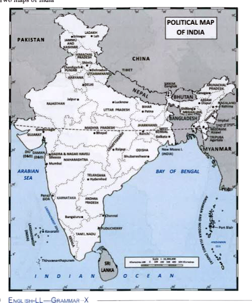
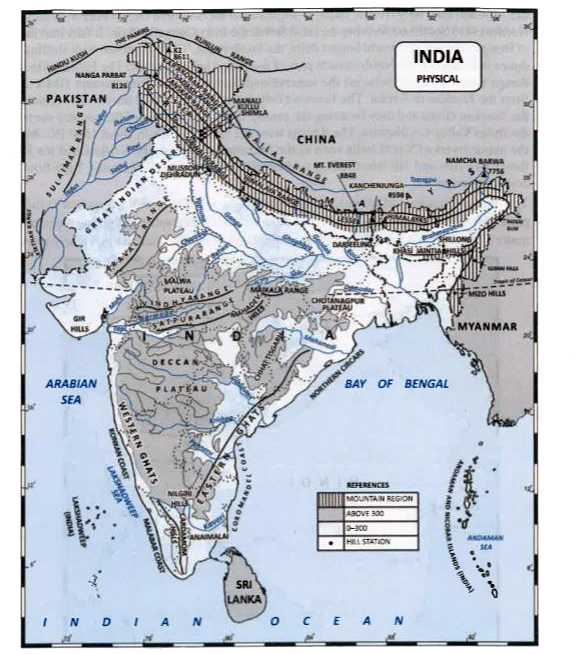
Two maps of India


Text Solution
There are 29 states and seven Union Territories in India. Each state and UT has administrative legislative and judicial capital. India borders Bangladesh, Bhutan, Myanmar, China, Nepal and Pakistan, It shares maritime borders with Thailand, Sri Lanka, Indonesia and the Maldives. The distance from the North to South is about 2930 km and from west coast to Gujarat to the border with Bangladesh in the east 2,040 km. India is the seventh largest country in the world and covers an area of 3,287, 263 km. It is the second most populous country in the world with 1.36 billion people in 2019. Every fifth person in this world is an Indian. The Himalayas in the north have some of the highest peaks in the world. The Ganges (Ganga) is the 2500 km long holy river in India. It originates in the Southern Great Himalayas and flows Northwest to Southeast forming the most fertile the Indo-Gangetic Plain. It falls into the Bay of Bengal forming the world largest delta, the Sunderbans. The Thar desert with shifting sand dunes is located in the Northwestern part of the Indian sub-continent. The Eastern Mountain Range forms a barrier between the subcontinent and Myanmar. The Western Ghats spread from the Konkan to Kerala. The Eastern Ghats are not as green and thick with vegetation as the Western Ghats and they lie along the eastern coast. The history of the country starts with the Indus Valley Civilisation. The Aryans were the first to invade in about 1500 BC. Most of the major rivers of South India such as the Mahanadi, Godavri, the Krishna and the Kaveri flow eastwards and fall into the Bay of Bengal. The Narmada, Periyar and Tapti flow west and make estuaries.
|
Updated on:21/07/2023
Topper's Solved these Questions
- BOOK - FULL MARKSCHAPTER - COMPOSITION - II (WRITING ANALYTICAL PARAGRAPH ON MAP/CHART/REPORT/ LINE GRAPH)EXERCISE - ANALYTIC STUDY OF REPORTS3videos
COMPOSITION - II (WRITING ANALYTICAL PARAGRAPH ON MAP/CHART/REPORT/ LINE GRAPH)
- BOOK - FULL MARKSCHAPTER - CLOZE PASSAGEEXERCISE - Fill in the most appropriate option in each blank from those given below to complete the following passage.112videos
CLOZE PASSAGE
- BOOK - FULL MARKSCHAPTER - COMPOSITION-IEXERCISE - IV. OFFICIAL LETTERS ON ALL SITUATIONS (SOLVED EXAMPLES)29videos
COMPOSITION-I
Similar Questions
Knowledge Check
- Question 1 - Select One
Who prepares the topographical maps of India ?
AGeological Servey of IndiaBSurvey of IndiaCDefence MinistryDGeographical Servey of India - Question 2 - Select One
Which or ganisation prepares topographical maps of India ?
AGeological Survery of IndiaBArchaeological Survery of IndiaCSurvery of IndiaDNational Atlas and Thematic Mapping Organisation
Which department prepares the weather map of India for each day?
View SolutionName the two southernmost neighbours of India.
View SolutionName the easternmost neighbour of India.
View SolutionName the northernmost neighbour of India.
View SolutionLocate on an outline map of India, isotherms in India in January and July.
View SolutionOn the outline map of India provided :
Shade and label a region with Red soil in India.View Solution

