Complete Solutions to ADDITIONAL QUESTIONS WITH ANSWERS ( VII. MAP/DIAGRAM QUESTIONS ) of chapter NATURAL HAZARDS ANS DISASTERS of Class 11 book with complete answers and questions
| Class 11 | GEOGRAPHY |
| Chapter | NATURAL HAZARDS ANS DISASTERS |
| NCERT | ADDITIONAL QUESTIONS WITH ANSWERS ( VII. MAP/DIAGRAM QUESTIONS ) |
| Number Of Questions | 10 |
| Academic Year | 2023-24 |
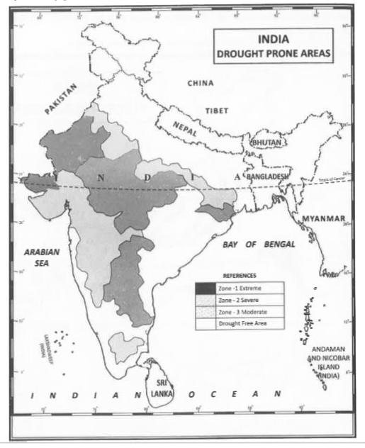
study the map given below and answer the questions that follow :

(i) Define the term drought .
(ii ) what is agricltural drought
(iii) mention the extreme drought affected area .
View SolutionLocate and label ten flood prone areas on an outline map of india
View SolutionLocate and label drought prone areas on an outline map of india .
View SolutionLocate and label earthquake prone areas on an outline map of india .
View SolutionOn the outline map of India mark and indicate the following features:
Very high damage risk zone-A
View SolutionOn the outline map of India mark and indicate the following features:
Very high damage risk zone-B
View SolutionOn the outline map of India mark and indicate the following features:
High damage risk zone
View SolutionOn the outline map of India mark and indicate the following features:
Moderate damage risk zone-A
View SolutionOn the outline map of India mark and indicate the following features:
Moderate damage risk zone-B
View SolutionOn the outline map of India mark and indicate the following features:
Low damage risk zone
View Solution
ADDITIONAL QUESTIONS WITH ANSWERS ( VII. MAP/DIAGRAM QUESTIONS ) questions and complete solutions for chapter NATURAL HAZARDS ANS DISASTERS of FULL MARKS GEOGRAPHY (HINGLISH) of Class 11
All Exercises from NCERT Class 11 GEOGRAPHY NATURAL HAZARDS ANS DISASTERS
- ADDITIONAL QUESTIONS WITH ANSWERS ( I. MULTIPLE CHOICE QUESTIONS )
- ADDITIONAL QUESTIONS WITH ANSWERS ( II. TABLE BASED QUESTIONS )
- ADDITIONAL QUESTIONS WITH ANSWERS ( III. VERY SHORT ANSWER QUESTIONS )
- ADDITIONAL QUESTIONS WITH ANSWERS ( IV. SHORT ANSWER TYPE QUESTIONS )
- ADDITIONAL QUESTIONS WITH ANSWERS ( V. LONG ANSWER TYPE QUESTIONS )
- ADDITIONAL QUESTIONS WITH ANSWERS ( VI. HOTS QUESTIONS )
- ADDITIONAL QUESTIONS WITH ANSWERS ( VII. MAP/DIAGRAM QUESTIONS )
- NCERT TEXTBOOK QUESTIONS WITH ANSWERS