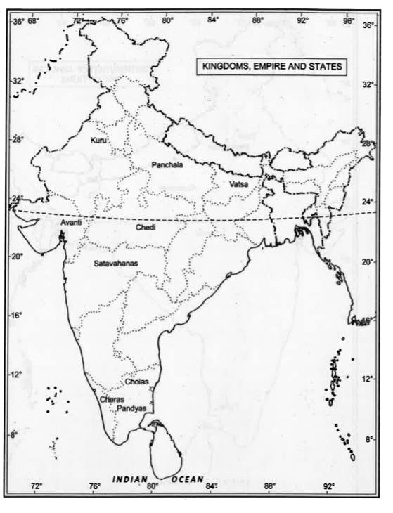
On a map of India, mark and name the following:
(a) Cholas, Chera, Pandyas Kingdoms and Satavahanas empire.
(b) Any five major states of 6th century CE.
Topper's Solved these Questions
- KINGS, FARMERS AND TOWNSBOOK - FULL MARKSCHAPTER - KINGS, FARMERS AND TOWNSEXERCISE - ADDITIONAL QUESTIONS SOLVED (Map Based Questions)
1 Videos
- KINGS AND CHRONICLES THE MUGHAL COURTS BOOK - FULL MARKSCHAPTER - KINGS AND CHRONICLES THE MUGHAL COURTS EXERCISE - Test Your Skill
5 Videos
- KINSHIP, CASTE AND CLASS EARLY SOCIETIES BOOK - FULL MARKSCHAPTER - KINSHIP, CASTE AND CLASS EARLY SOCIETIES EXERCISE - PREVIOUS YEARS BOARD QUESTIONS SOLVED
29 Videos
Similar Questions
On the given political outline map of India mark and name the following: (a) Kuru (b) Rajgir (c) Magadha (d) Avanti (e) Ujjain
View SolutionOn the map of India, mark and locate the following 16−17th century cities of Southern India.
1. Bijapur 2. Warangal 3. Thanjavur 4. Quilon 5. Golconda 6. Kanchipuram 7. Vijayanagara 8. Bidar 9. Chandragiri 10. Madurai 11. Mysore 12. Kolar 13. Tirunelveli
View Solution
Knowledge Check
Consider the following statements :
1. The Cholas defeated Pandya and Chera rulers and established their domination over penisular India in the early medieval times.
2. The Cholas sent an expendition against Sailendra empire of South East Asia and conquered some of the areas.
Which of these statements is /are correct ?AOnly 1BOnly 2CBoth 1 and 2DNeither 1 nor 2Consider the following statements:
1. The Cholas defeated Pandya and Chera rulers and established their domination over peninsular India in the early medieval times.
2. The Cholas sent an expedition against Sailendra empire of Southeast Asia and conquered some of the areas
Which of these statements is/are correct ?AOnly 1BOnly 2CBoth 1 and 2DNeither 1 nor 2Which of the following is NOT one of the monarchical states that existed in the 7th and early 6th centuries BC in India?
AMagadhaBVaishaliCAvantiDKosala
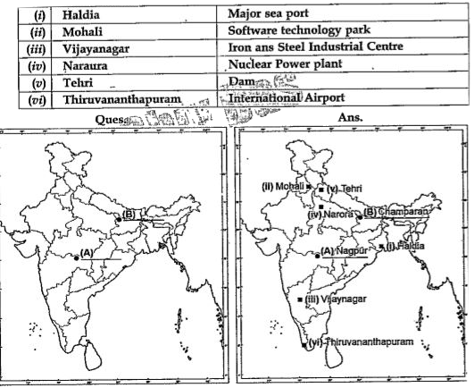
(a) One feature A is shown in the given political outline map of India. Identify this feature with the help of the following information and write its correct name on the line marked on the map: (A) A soil type
(b) On the same political outline map of India, locate and label the following features with appropriate symbols: (B) Bhakra Nangal Dam (C) A State which is the major producer of Cotton
View SolutionStudy the given map showing dairy farming regions carefully and answer the questions that follow:
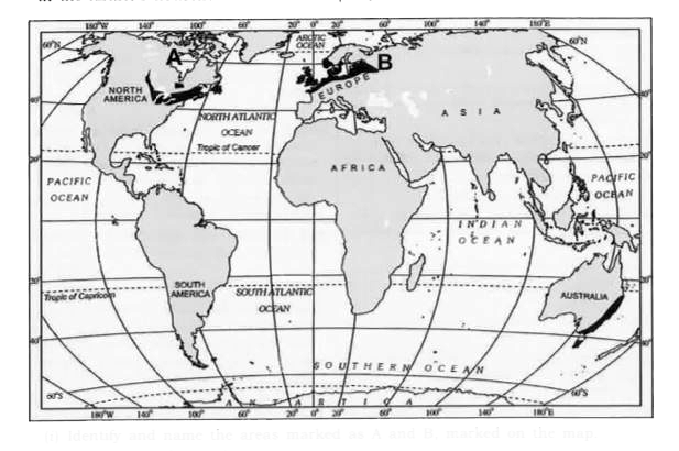
(i) Identify and name the areas marked as A and B, marked on the map.
(ii) Define 'dairy farming'.
(iii) Explain any three characteristics of dairy farming.
View Solution(a) Two places 'A' and 'B' are marked on the given political outline map of India. Identify them and write their correct names on the lines drawn near them. 2 (A) The place where the Indian National Congress Session was held. (B) The place where Indigo Planters organized Satyagraha. (b) On the same outline Map of India, locate and label any four of the following with appropriate symbols:
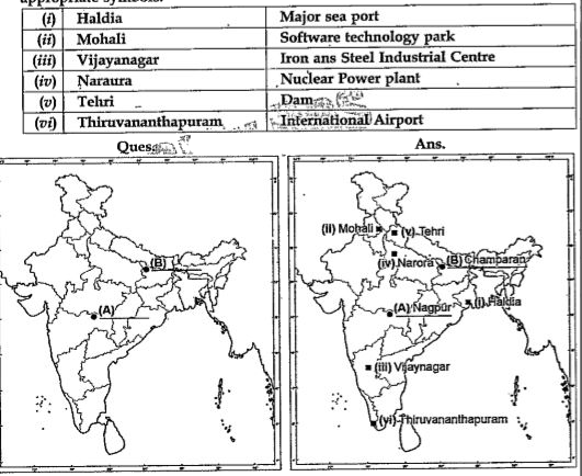
Name the state where Jallianwala Bagh incident took place.
View Solution(a) Two places 'A' and 'B' are marked on the given political outline map of India. Identify them and write their correct names on the lines drawn near them. 2 (A) The place where the Indian National Congress Session was held. (B) The place where Indigo Planters organized Satyagraha. (b) On the same outline Map of India, locate and label any four of the following with appropriate symbols:
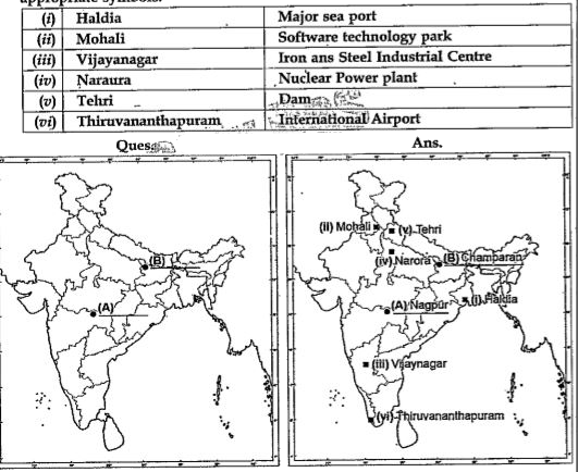
Name the state where Indigo Planters organised Satyagraha.
View Solution(a) Two places 'A' and 'B' are marked on the given political outline map of India. Identify them and write their correct names on the lines drawn near them. 2 (A) The place where the Indian National Congress Session was held. (B) The place where Indigo Planters organized Satyagraha. (b) On the same outline Map of India, locate and label any four of the following with appropriate symbols:
Name the state where Tarapur nuclear power plant is located.
View Solution
