River Ganga cmcrgcs on the plains at
A
Devprayag
B
Haridwar
C
Ambala
D
Mithankot
Text Solution
The correct Answer is:B
|
Updated on:21/07/2023
Topper's Solved these Questions
- BOOK - MCGROW HILL PUBLICATIONCHAPTER - RIVER SYSTEMS AND CLIMATE IN INDIA EXERCISE - HIGHER ORDER THINKING QUESTIONS20videos
RIVER SYSTEMS AND CLIMATE IN INDIA
- BOOK - MCGROW HILL PUBLICATIONCHAPTER - RESOURCES FOR HUMAN NEEDS EXERCISE - HIGHER ORDER THINKING QUESTIONS20videos
RESOURCES FOR HUMAN NEEDS
- BOOK - MCGROW HILL PUBLICATIONCHAPTER - WATER RESOURCES AND AGRICULTUREEXERCISE - HIGHER ORDER THINKING QUESTIONS20videos
WATER RESOURCES AND AGRICULTURE
Similar Questions
Knowledge Check
- Question 1 - Select One
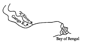
The tributary of river Ganga marked 'X' in the given map is which of the following?
 AGandakBSoneCGhangharaDKosi
 - Question 2 - Select One
Total length of River Ganga drainage basin is
A2500 kmB2900 kmC2700 kmDNone of these - Question 3 - Select One
The river Ganga emerges from Gangotri Glacier and ends at ______.
APacific OceanBArabian SeaCBay of BengalDIndian Ocean
From where does the river Ganga originate and which tributaries join it?
View SolutionThe river Ganga emerges from Gangotri Glacier and ends at
View SolutionThe river Ganga emerges from Gangotri Glacier and ends at
View SolutionRiver Sarda drains in the Northern Plains of Uttar Pradesh Before entering in the Plains, Sarda is known as
View SolutionThe Indus in the west and the Ganga-Brahmaputra in the east are the river streams which constitute the
View Solution

