Complete Solutions to MCQs of chapter GEOGRAPHY OF INDIA of Class 12 book with complete answers and questions
| Class 12 | GEOGRAPHY |
| Chapter | GEOGRAPHY OF INDIA |
| NDA PREVIOUS YEAR | MCQs |
| Number Of Questions | 100 |
| Academic Year | 2023-24 |
Which one among the following is nearest to the Tropic of Cancer?
View SolutionIn India, in which one of the following areas are the tropical evergreen forests found ?
View SolutionMatch List-I (Atomic Power Plant) with List-II (State ) and select the correct answer using the codes given below the Lists:
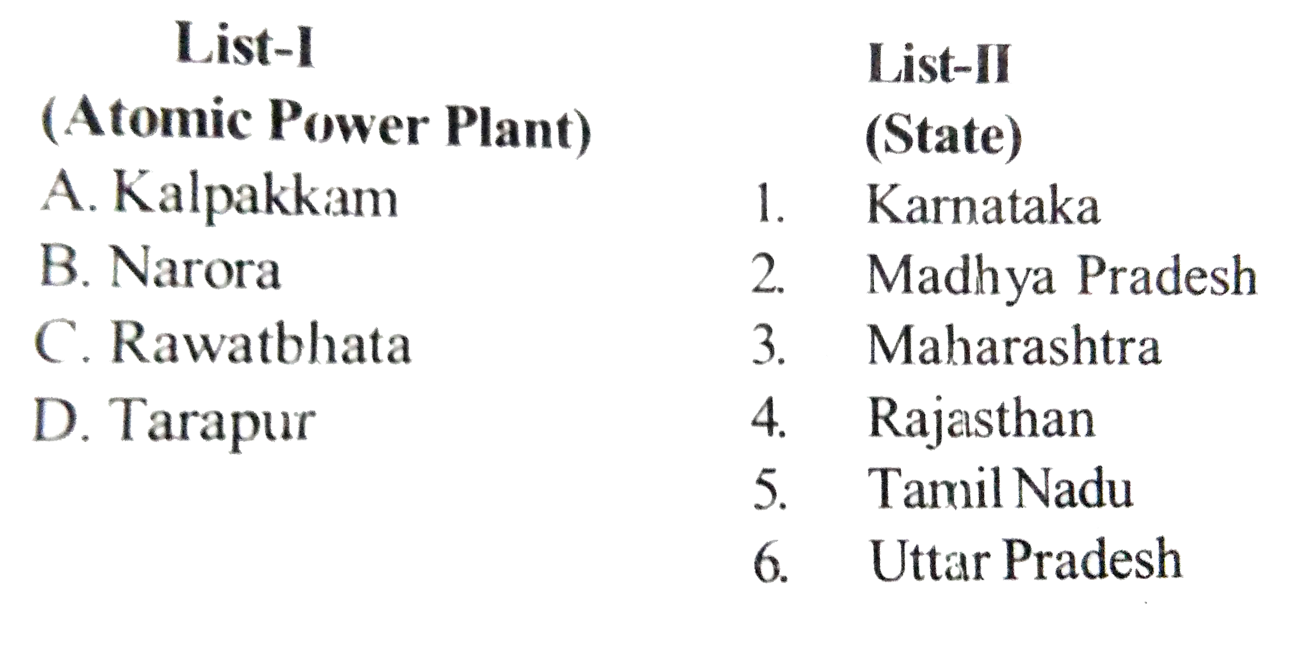
View SolutionMatch List- (Town) with List-II (Factory/Plant) and select the correct answer using the codes given below the Lists:

View SolutionWhich one of the following towns is well-known for its aluminium industry?
View SolutionAt which one of the following towns do National Highways Nos. 6 and 7 cross each other ?
View SolutionAs per the census of 2001, which one of the following is the correct sequence of states in descending order of their population?
View SolutionWhich one of the following pairs is not correctly matched ?
View SolutionIn which one of the following states is Zojila pass located?
View SolutionMatch List-I (Town) with List-II (River) and select the correct answer using the codes given below the Lists:

View SolutionWhich of the following pairs is/are correctly matched ?
1.Hirakud Reservoir: Sambalpur
2 Ukai Reservoir: Amravati
3.Tawa Reservoir : Pachmarhi
Select the correct answer using the code given below
View SolutionConsider the following statements:
1. In the coastal regions, the land breeze blows over to the sea during night.
2 In the coastal regions, during night, the air over the sea is warmer than the air over land
Which of the statements given above is/are correct?
View Solution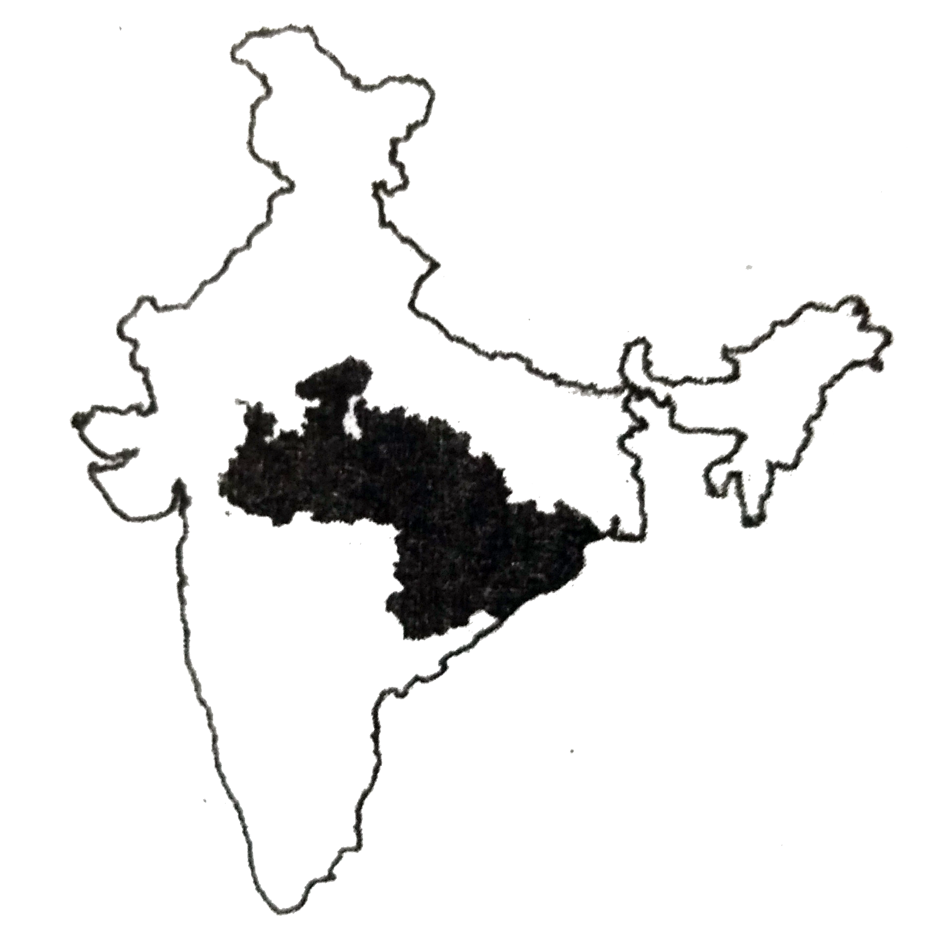
In the map given above, what is the population density in the region represented by the shaded area ?
View Solution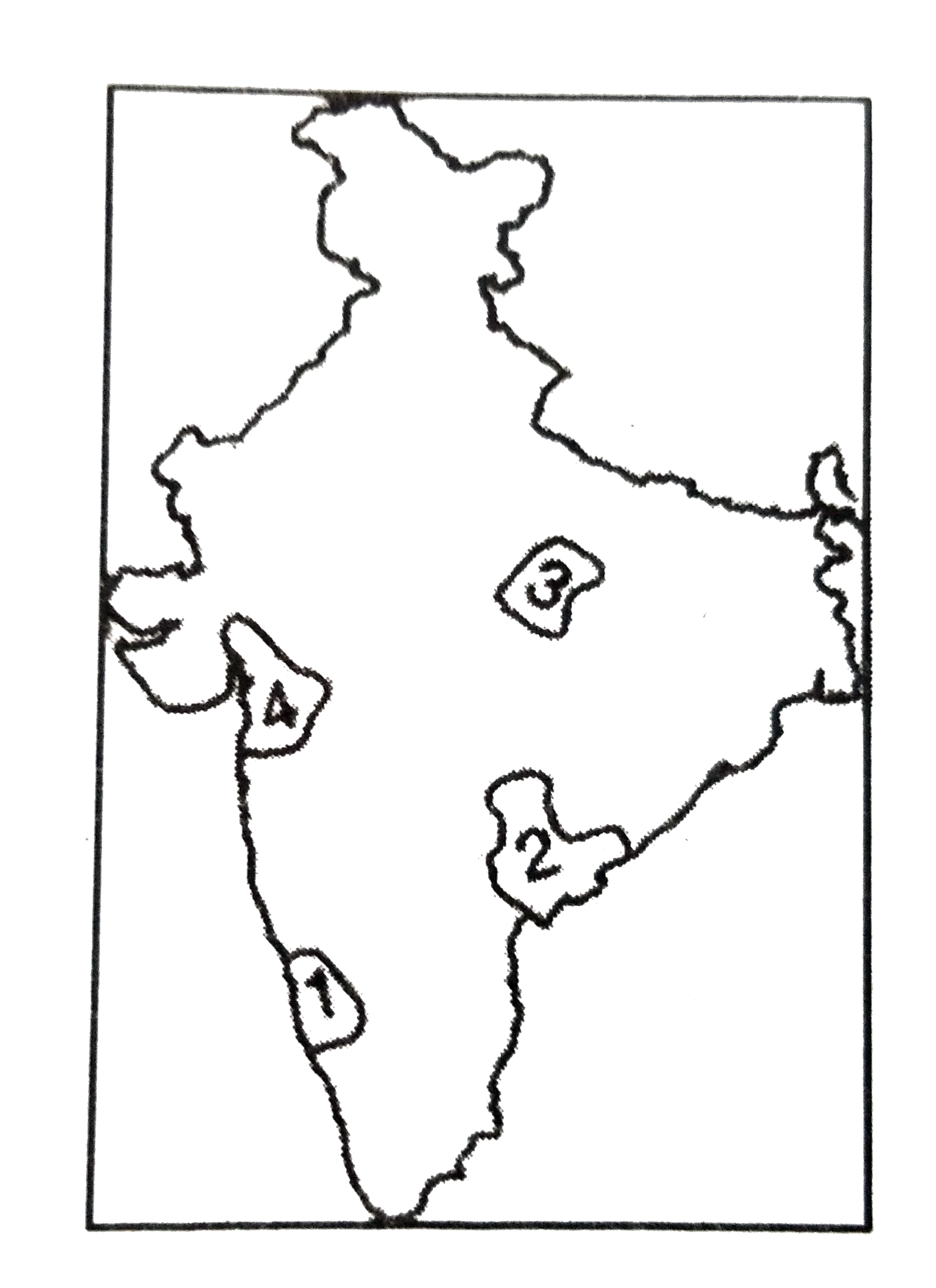
In the map given above, out of the four areas represented by number 1 to 4, which of them represent tobacco growing areas?
View SolutionConsider the following statements on the basis of Census 2001
1. in Kerala, the sex ratio is in favour of females.
2 Next to Kerala, Mizoram has the highest literacy rate in India.
Which of the statements given above is/are correct ?
View SolutionWhich one of the following National Highways links Jabalpur, Nagpur, Hyderabad, Bangalore and Madurai ?
View SolutionWhich one of the following pairs is not correctly matched ?
View SolutionMatch List-I and List-II and select the correct answer using the codes given below:
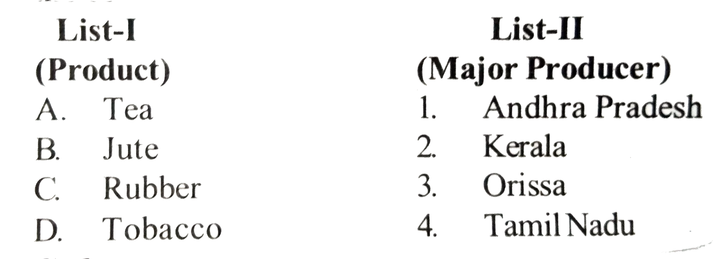
View SolutionWhere is the Nanda Devi peak located ?
View SolutionThe river Sone is a tributary of which one of the following rivers?
View SolutionSandstone is a
View SolutionWhich one of the following is the correct sequence of passes when one travels along the Himalayas from Kashmir to Sikkim?
View Solution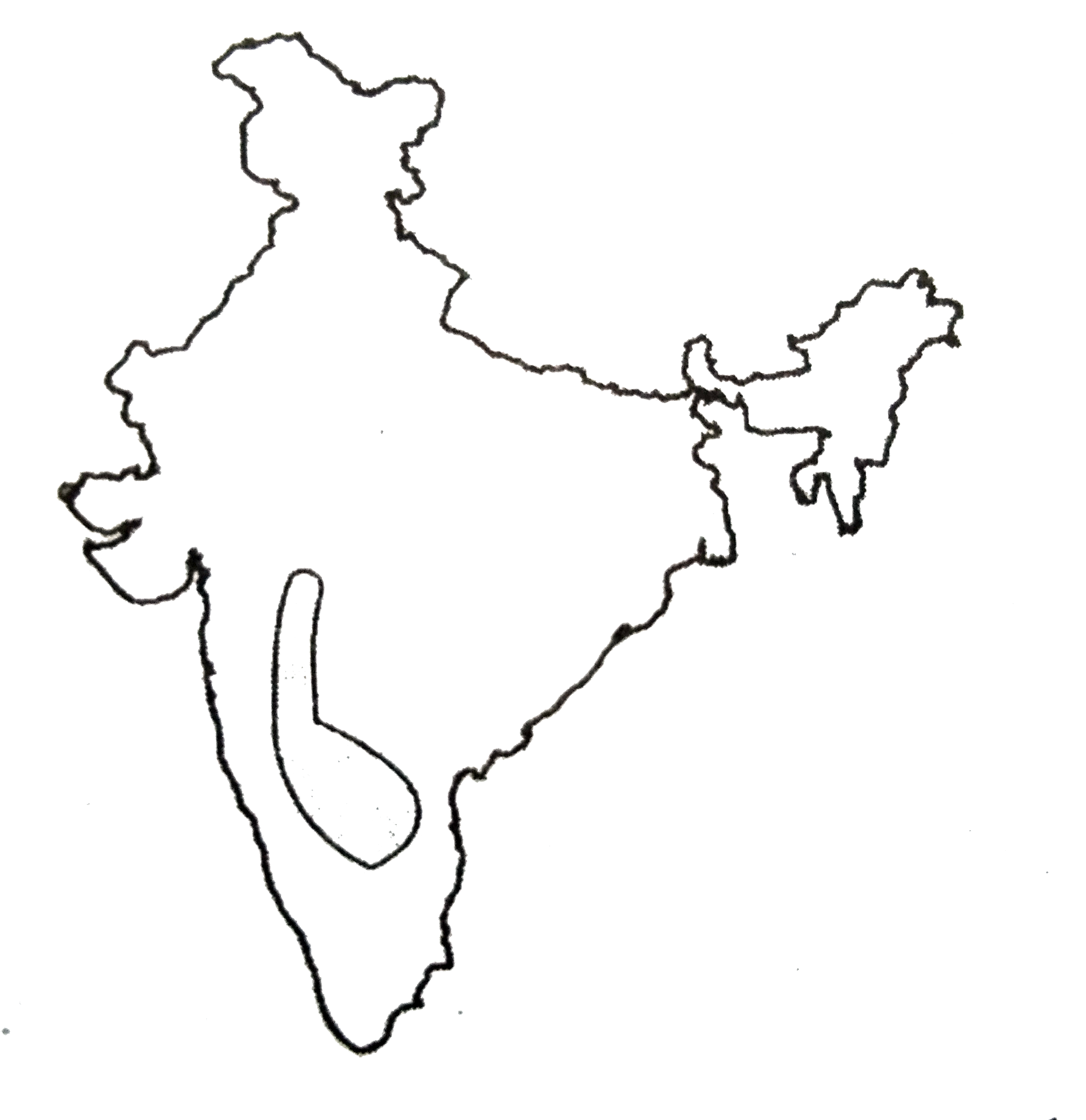
In the above map, the marked area shows which one of the following ranges of annual rainfall received by that area?
View SolutionConsider the following statements:
1.Ranjit Sagar Dam is on the river Beas.
2.Hirakud Dam is on the river Damodar.
3.The reservoir Gandhi Sagar is on the river Chambal.
Which of the statements given above is/are correct?
View SolutionWhich one among the following states has more population than the other three?
View SolutionMatch List I with List II and select the correct answer using the code given below the Lists:
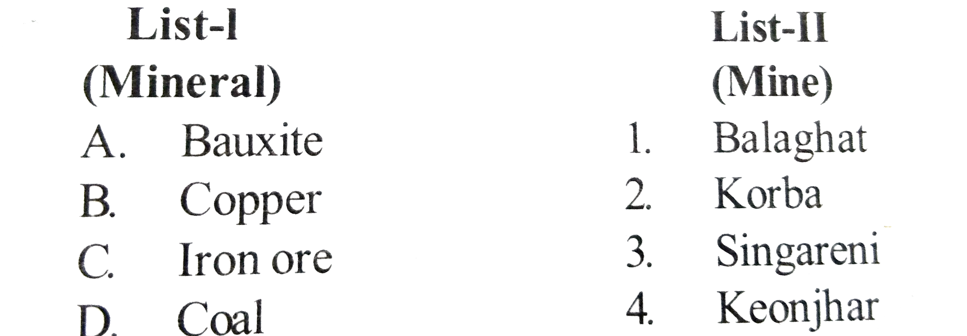
View SolutionMatch List I with List II and select the correct answer using the code given below the Lists :
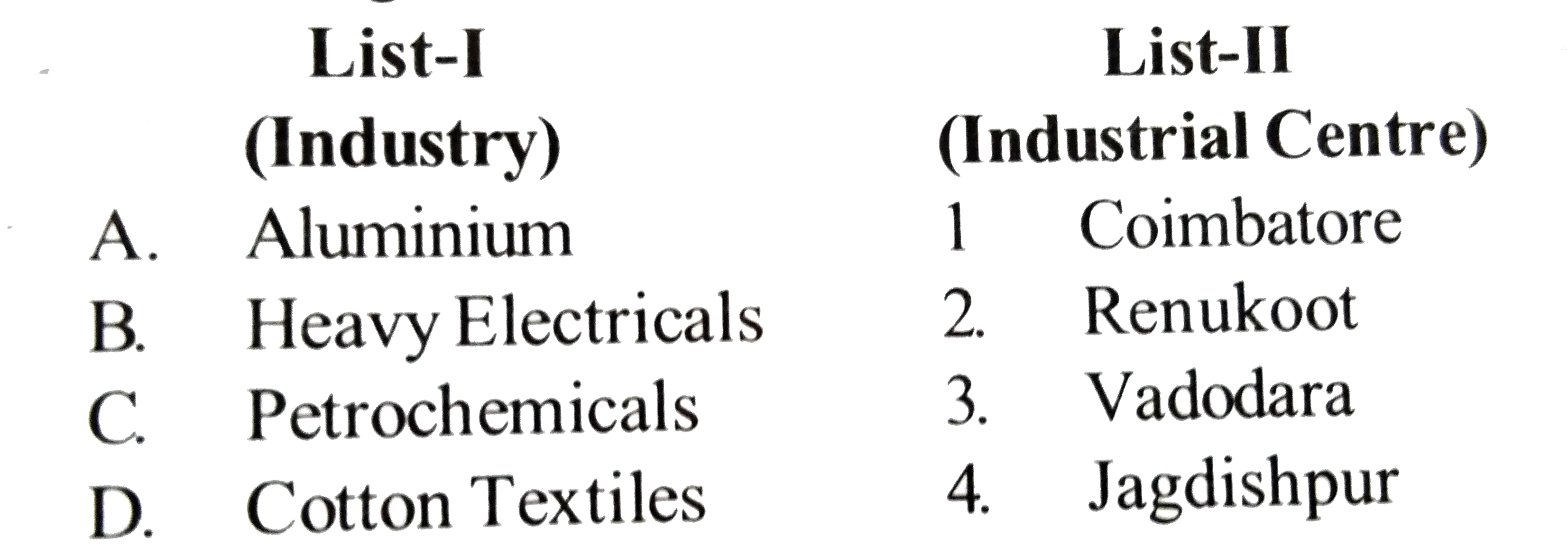
View SolutionMatch List I with List II and select the correct answer using the code given below the Lists :

View SolutionWhich one of the following pairs is correctly matched?
View SolutionWhen it is 12 Noon at Allahabad, the time at Wellington (New Zealand) would be close to which one of the following?
View SolutionConsider the following statements:
1.Alamatti dam is on the Cauvery river
2.Mettur dam in on the Krishna river
3.Gandhi Sagar Reservoir is on the Chambal river.
Which of the statements given above is/are correct?
View SolutionWhich National Highway connects Delhi and Mumbai?
View SolutionWhich one among the following peaks is the highest?
View SolutionFrom West to East, which one of the following is the correct sequence of Hills?
View SolutionHaridwar is well-known for which one of the following industries?
View SolutionThe Tropic of Cancer passes through which one of the following?
View SolutionIn which of the following Hills is tea cultivated?
View SolutionIndia is comparatively not rich in which one of the following minerals compared to the other three?
View SolutionAmong the following, which one has recorded the highest population growth rate during 1991-2001 ?
View SolutionThe Nuclear Power Station Rawatbhata is in which State ?
View SolutionMahatma Gandhi Hydroelectric project is on which
View SolutionFor which one of the following is Lamba in Gujarat, famous?
View SolutionConsider the following statements
1.Kandla port is situated at the head of Gulf Of khambhat
2 Paradeep Port is situated in the Mahanadi Delta.
Which of the statements given above is/are correct ?
View SolutionThe National Highway No. 7 connects which of the following?
View SolutionPort Blair-the capital of Andaman and Nicobar Islands, is located in which one of the following islands?
View SolutionAmong the following, which state has highest level of literacy?
View SolutionWhich among the following is the major item of export from Paradeep Port?
View SolutionIndian Standard Time refers to the local time of which one of the following places in India?
View SolutionConsider the following rivers:
1.Betwa
2 Kosi
3 Gandak
Which of the above join(s) Yamuna river?
View SolutionWhich one of the following types of forest covers the maximum area in India?
View SolutionWhich one of the following rivers flow between Vindhya and Satpura ranges?
View SolutionAmravati, Bhavani, Hemavati and Kabini are tributaries of which one of the following rivers?
View SolutionWhich one of the following sets of States does not receive most of its rainfall from SW monsoon during the months of June to September?
View SolutionMatch list I with List II and select the correct answer using the codes given below the lists
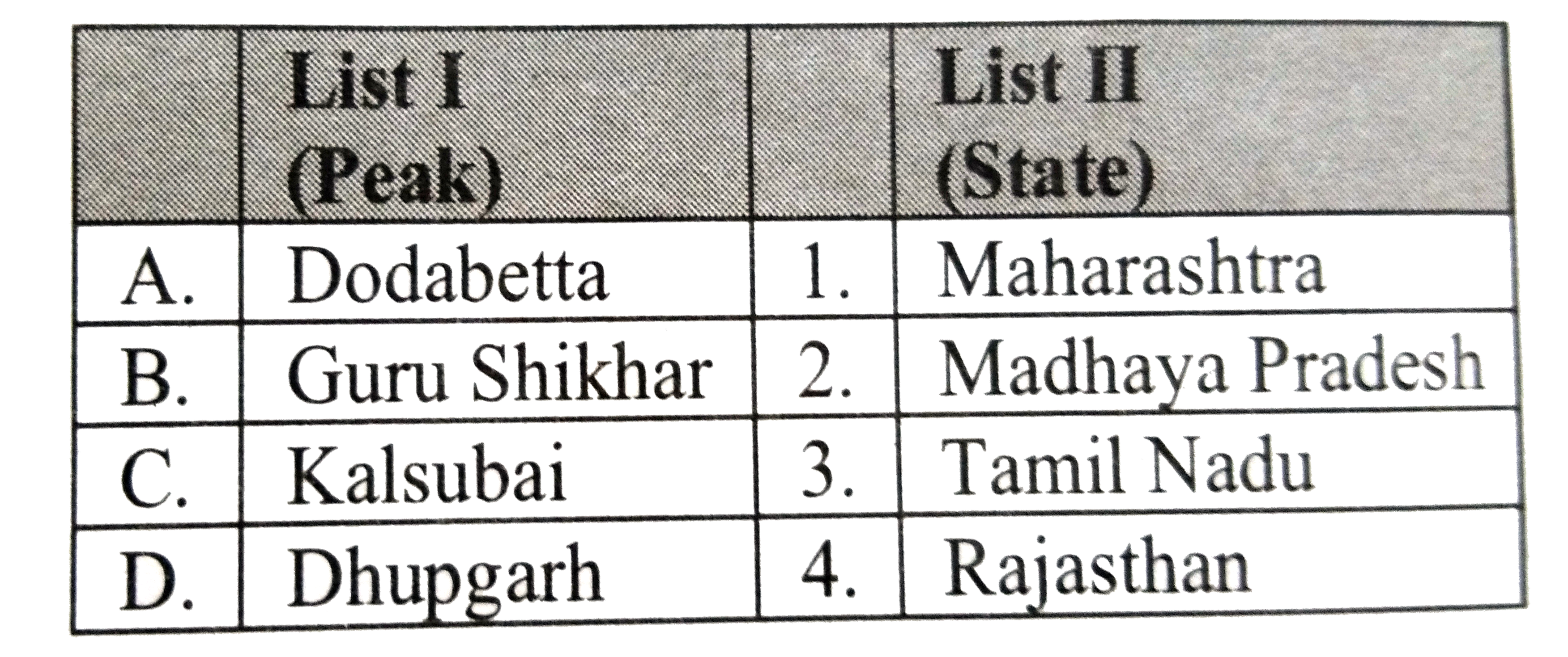
View SolutionMatch list I with List II and select the correct answer using the codes given below the lists
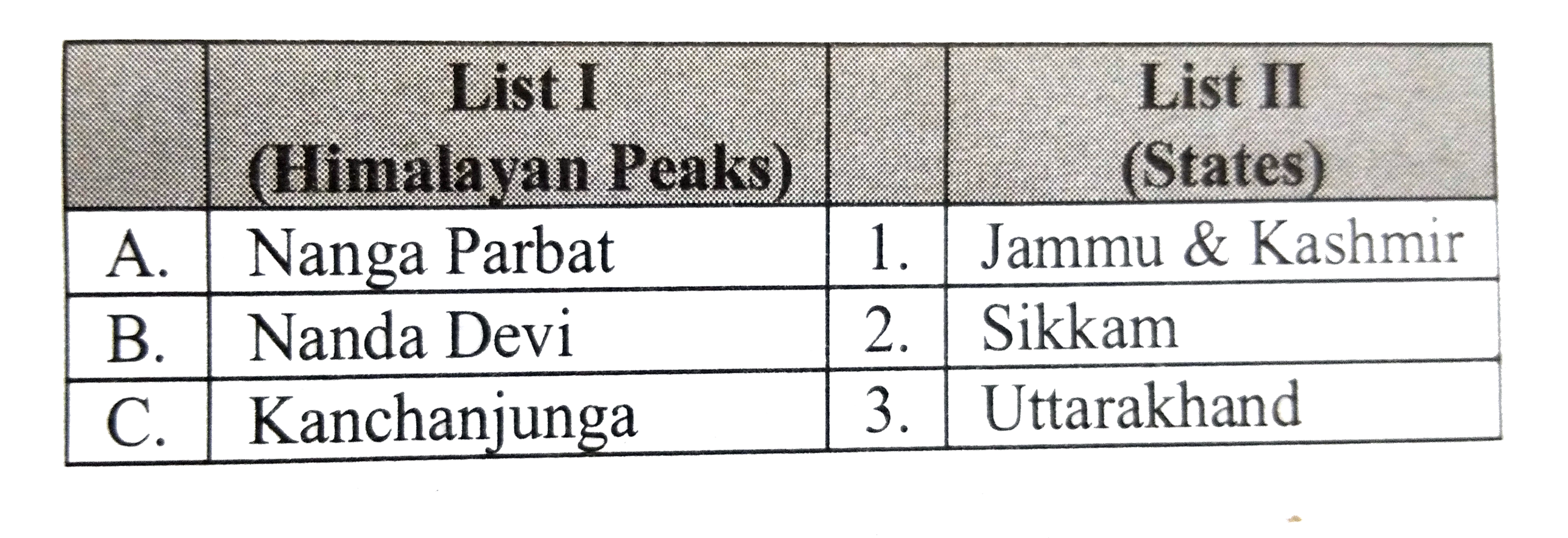
View SolutionWhich among the following is the correct sequence of rivers starting from North to South ?
View SolutionShimsha, Hemavathi, Arkavati are the tributaries of which one of the following rivers?
View SolutionChambal river is a part of
View SolutionMatch list I with List II and select the correct answer using the codes given below the lists

View SolutionWhat is the reason for India being a major producer of different varieties of fruits and vegetables?
View SolutionWhat is the sequential order of vegetation types observed while moving from Assam Valley to Rajasthan Plains?
View SolutionThe Tropic of Cancer does not pass through
View SolutionIron ore from Kudremukh is most likely to be exported through
View SolutionMatch list I with List II and select the correct answer using the codes given below the lists
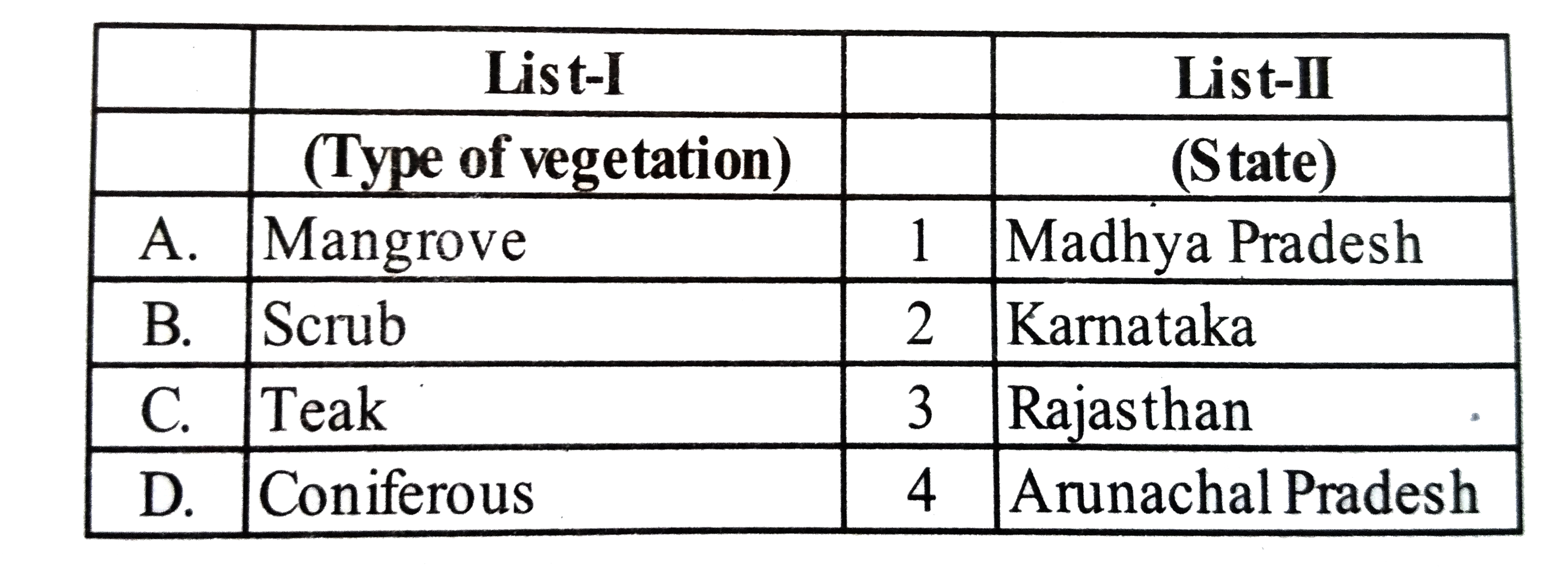
View SolutionArrange the following States on the basis of ascending dates of the onset of monsoon:
1.Uttar Pradesh, 2 West Bengal, 3 Kerala, 4 Rajasthan
Select the correct answer using the code given below
View SolutionWhich of the following are west flowing rivers?
1 Krishna , 2 Narmada, 3 Mahanadi, 4 Sabarmati
Select the correct answer using the code given below:
View SolutionWhich of the following has have been declared as national waterways in India?
I. The Allahabad-Haldia stretch of river Ganga
II. The Sadiya-Dhubri stretch of river Brahmaputra
III. The Cherla-Rajamundry stretch of river Godavari
Select the correct answer using the code given below
View SolutionWhich of the following statements is/are correct?
I.Mumbai receives more rainfall than Pune because it is located at the windward side of Western Ghats
II. Vidarbha region experiences semi-arid climate as it is located in a rain shadow region
III. In India monsoon reaches Kashmir valley at the last
Select the correct answer using the code given below
View SolutionWhich of the following statements regarding south-west monsoon in India is/are correct ?
I.Monsoon reaches the Malabar coast first
II.Rajasthan does not get rainfall from south west monsoon
III.South-west monsoon retreats when the permanent wind belts start shifting to the south
Select the correct answer using the code given below
View SolutionConsider the following statements
I. In India, the largest concentration of rods is found in the northern plains
II. The ratio of surfaced road to the total road length is lower in the northern plains
Which of the statements given above is are correct?
View SolutionWhich one of the following does not characterise the Himalayas?
View SolutionWhich among the following statements provides the best evidence that a river is flowing through a rift valley ?
View SolutionMatch List I with List Il and select the correct answer using the code given below the lists
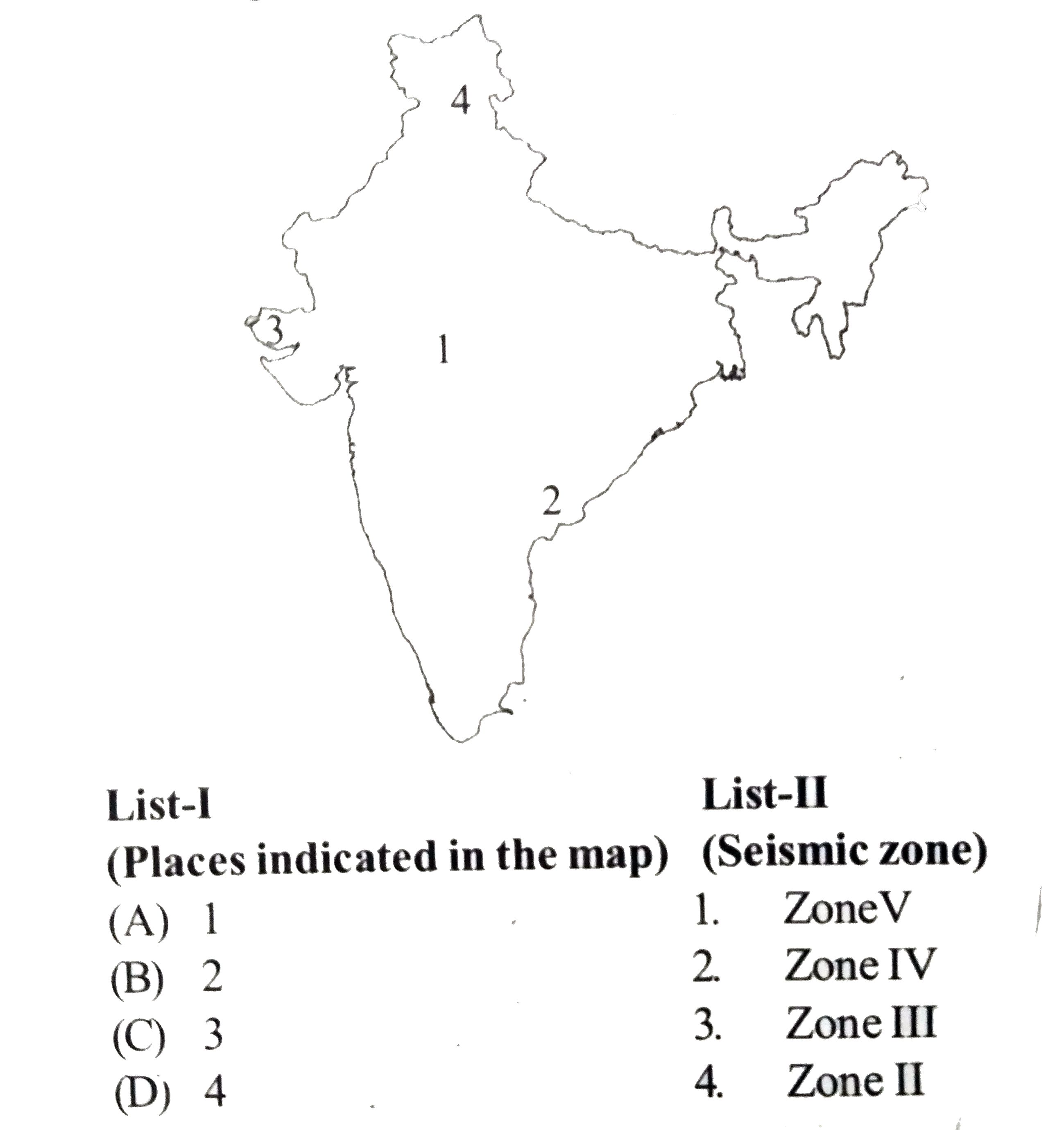
View SolutionThe Narmada river in the Peninsular plateau flows westward with a remarkably straight channel. It is because the
View SolutionWhy the summer monsoon winds blow from south-western direction in the northen hemisphere?
View SolutionConsider the following statements
1.The Himalayan vegetation varies according to both altitude and climatic conditions
2.There are mainly two types of tropical forests that are found in the Himalayas-the tropical rainforests and the tropical deciduous forests.
Which of the statements given above is are correct?
View SolutionWhich one among the following is not a reason for practising tank irrigation in Peninsular India?
View SolutionIdentify from the following states of India through which the Tropic of Cancer passes and arrange them from East to West
1.Gujarat , 2.West Bengal , 3.Uttar Pradesh , 4.Jharkhand , 5.Madhya Pradesh , 6.Bihar , 7. Chhattisgarh
Select the correct using the codes given below :
View SolutionWhich one among the following is a correct sequence of the Indian ports from north to south?
View SolutionWhich one among the following is a correct sequence of production of coal in the Indian States in descending order?
View SolutionMatch List I with List II and select the correct answer using the code given below the lists
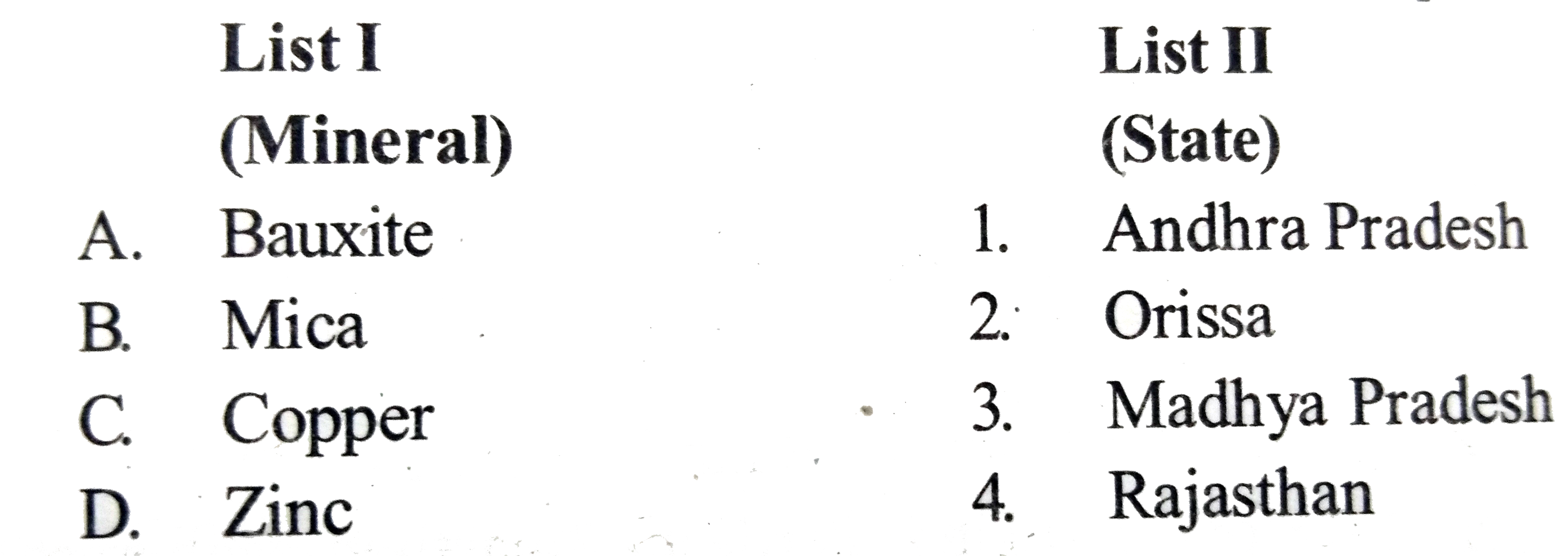
View SolutionThe western coasts of India receive very high rainfall in summer mainly due to
View SolutionThe Gulf of Mannar is situated along the coast of
View SolutionThe river with highest tidal bore in India is
View SolutionThe Indian Standard Time(IST) is based on
View SolutionMatch List I with List II and select the correct answer using the code given below the lists
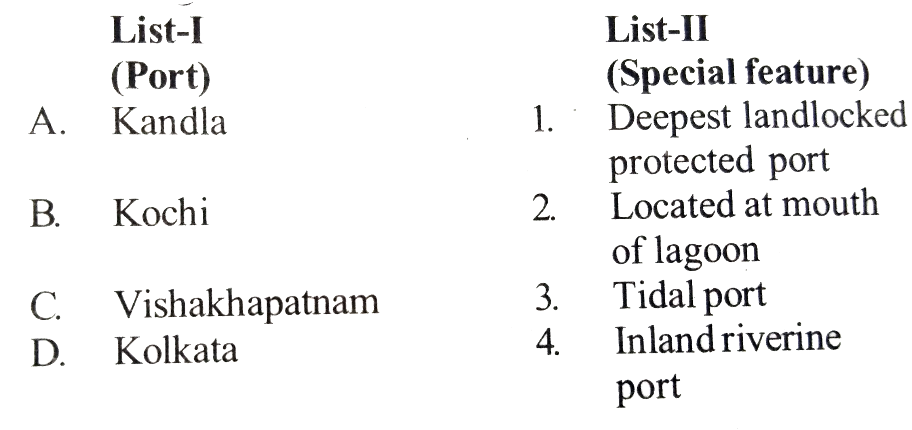
View SolutionConsider the following coal mines of India:
1.Bokaro ,2. Adilabad, 3. Raniganj ,4 Bishrampur
Select the correct sequence of the above from east to west
View SolutionWhich one among the following is the major reason for low agricultural productivity in dry regions of India?
View SolutionWhich one among the following is the most important source of fish catch in India?
View SolutionThe Damuda series of Gondwana system has three stages, namely, Raniganj, Barren Rocks and Barakar. The middle stage is called Barren because
View SolutionMatch List I with List II and select the correct answer using the code given below the lists
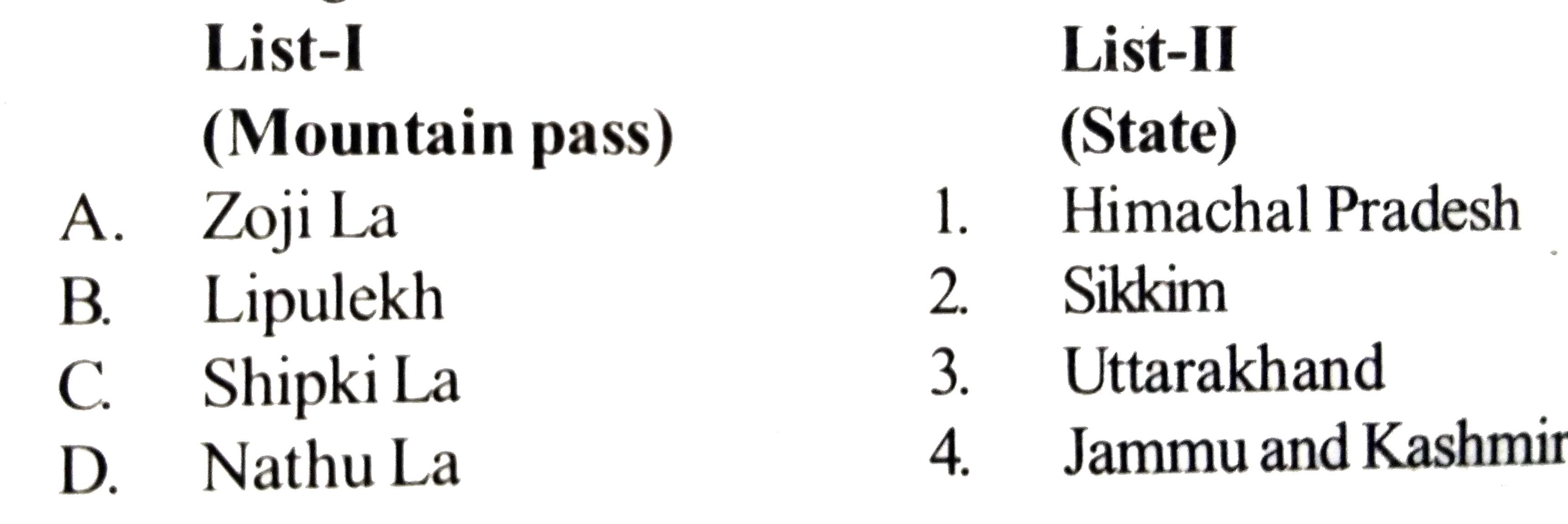
View SolutionMatch List I with List II and select the correct answer using the code given below the lists
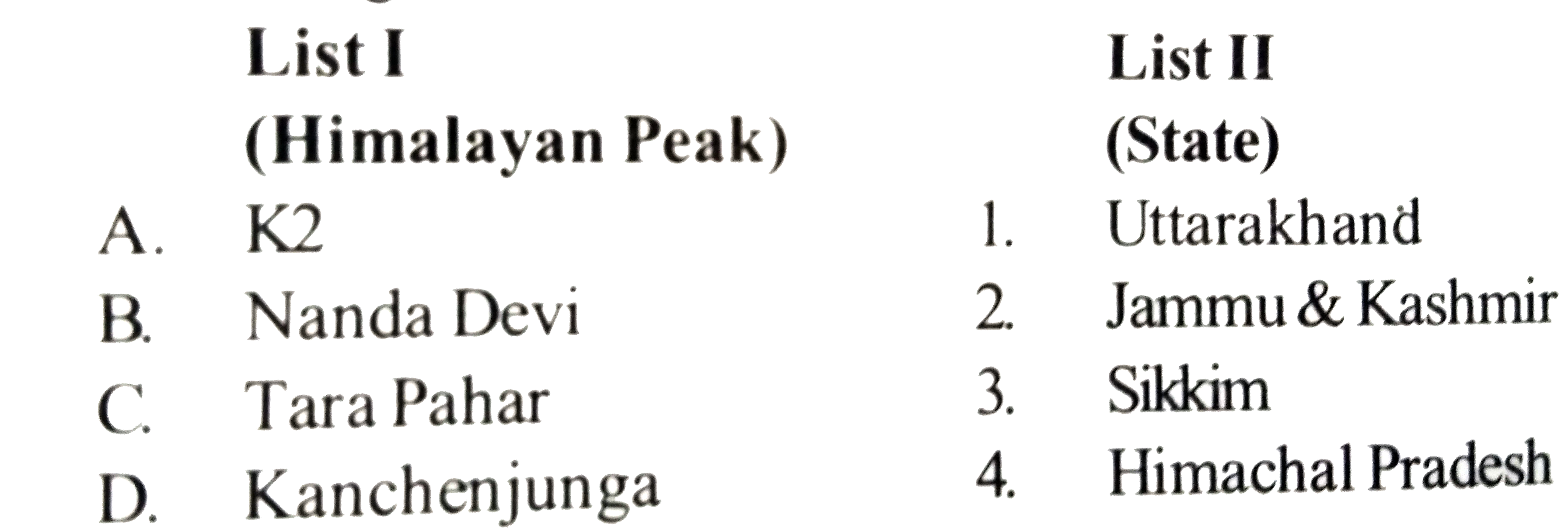
View SolutionThe Deccan Trap Formation was caused by
View SolutionWhich of the following statements is are correct?
1 Intertropical Convergence Zone is a low pressure belt which forms an important zone of contact over Northern India and Pakistan
2 Inter-Tropical Convergence Zone invites inflow of winds from different directions
Select the correct answer using the code given below:
View SolutionConsider the following statements regarding EI Nino effect on Indian Monsoon
1 The surface temperature goes up in the Southern Pacific Ocean and there is deficient rainfall in India.
2 The Walker Circulation shifts castward from its normal position and reduces monsoon rainfall in India.
Which of the statements given above is are correct?
View SolutionIn which among the following terrains the bore wells and canals can be dug casily ?
View SolutionWhich of the following statements is/are correct ?
1.The local time of Itanagar (Arunachal Pradesh) is about two hours ahead than Dwarka (Gujarat).
2 The local time at Chennai (Tamil Nadu) and Lucknow (Uttar Pradesh) is almost same
3.The local time of Mumbai (Maharashtra) is one hour ahead than Kolkata (West Bengal).
Select the correct answer using the code given below:
View SolutionMatch List I with List II and select the correct answer using the code given below the lists
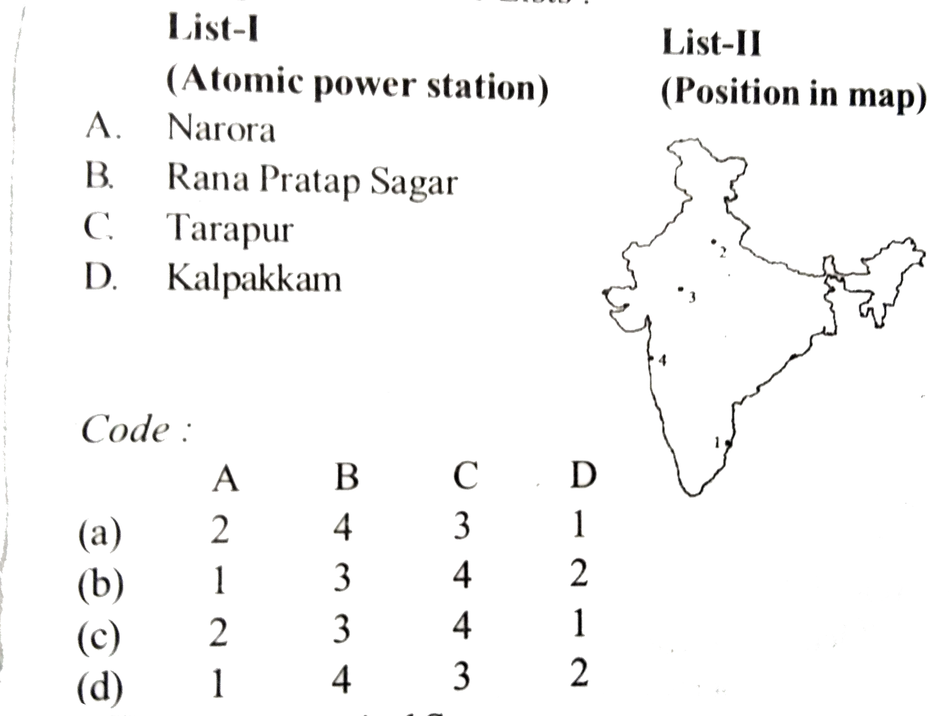
View SolutionIn India, the Tropical Savanna (A) type of climate prevails largely in
View SolutionThe Nokrek biosphere reserve is located in
View Solution
MCQs questions and complete solutions for chapter GEOGRAPHY OF INDIA of NDA PREVIOUS YEARS of Class 12