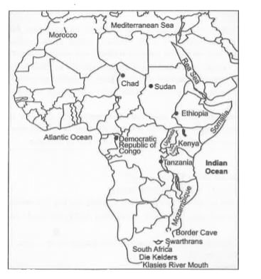
On the map of Africa mark and locate the sites related to early humans.
(i) Chad
(ii) Sudan
(iii) Ethiopia
(iv) Tanzania
(v) Democratic Republic of Congo
(vi) Mozambique
Topper's Solved these Questions
- FROM THE BEGINNING OF TIMEBOOK - FULL MARKSCHAPTER - FROM THE BEGINNING OF TIMEEXERCISE - More Question Solved ( IV. Passage Based Questions )
7 Videos
- DISPLACING INDIGENOUS PEOPLES BOOK - FULL MARKSCHAPTER - DISPLACING INDIGENOUS PEOPLES EXERCISE - MORE QUESTION SOLVED (MAP SKILLS)
2 Videos
- PATHS TO MODERNISATIONBOOK - FULL MARKSCHAPTER - PATHS TO MODERNISATIONEXERCISE - TEST YOUR SKILLS ( VERY SHORT ANSWER TYPE QUESTIONS)
3 Videos
Similar Questions
On the map of Australia mark and locate the following:
(i) Perth (ii) Sydney
(iii) Adelaide (iv) Darwin
(v) Melbourne (vi) Canberra
View SolutionOn the map of Western Europe mark and locate the following extent of feudalism:
(i) St. Denis (ii) Bingen (iii) London (iv) Rome (v) Vienna
View SolutionOn the given map of Britain, mark and locate the following iron and coal manufacturing areas.
(i) Leeds
(ii) Shefficld
(iii) Liverpool
(iv) Bristol
(v) Swansea
View SolutionOn the map of Britain, mark and locate the following cotton textile manufacturing areas.
(i) Newcastle (ii) Nottingham (iii) Birmingham (iv) Glasgow (v) Leicester (vi) London
View SolutionOn the given political map of India mark and label the given Harappan sites.
(i) Balakot (ii) Nageshwar (iii) Banawali (iv) Dholavira (v) Chanhudaro
View SolutionOn the given map of West Asia, mark and locate the following cities:
(i) Mecca (ii) Medina (iii) Damascus
(iv) Antioch (v) Edessa (vi) Armenia
(vii) Bukhara (viii) Samarqand
View SolutionOn the outline map of Western Himalayas mark and indicate the following features:
(i) K2 (ii) Nanga Parbat (iii) Kailash Range (iv) Pamir Knot (v) Shiwalik Range (vi) Zojila Pass
View SolutionOn the given map mark and locate the following Islamic land as depicted or described in this chapter.
(i) Fustat
(ii) Nishapur
(iii) Baghdad
(iv) Constantinople
(v) Medina.
View SolutionOn an outline map of India, mark and label the following:
(i) Nanda devi (ii) Panchmarhi (iii) Manas
(v) Similipal (iv) Nilgiri (vi) Bay of Mannar (vii) Great Nicobar (viii) Nokrek
(ix) Sunderbans (x) Achanakmar - Amarkantak.
View SolutionOn the outline map of India mark and indicate the following feature:
(i) Forests soils
(ii) Alluvial soils
(iii) Black soils
(iv) Red and yellow soils
(v) Laterite soils
(vi) Arid soils.
View Solution

