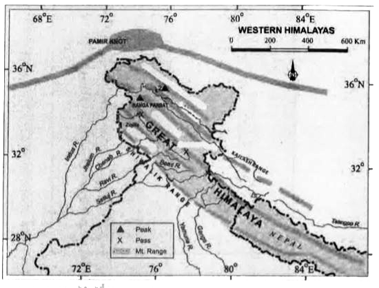
On the outline map of Western Himalayas mark and indicate the following features:
(i) K2 (ii) Nanga Parbat (iii) Kailash Range (iv) Pamir Knot (v) Shiwalik Range (vi) Zojila Pass
Topper's Solved these Questions
- STRUCTURE AND PHYSIOGRAPHYBOOK - FULL MARKSCHAPTER - STRUCTURE AND PHYSIOGRAPHYEXERCISE - Additional Questions With Answers (V. Hots Questions)
2 Videos
- SOLAR RADIATION, HEAT BALANCE AND TEMPERATUREBOOK - FULL MARKSCHAPTER - SOLAR RADIATION, HEAT BALANCE AND TEMPERATUREEXERCISE - ADDITIONAL QUESTIONS WITH ANSWER MAP SKILL
1 Videos
- TOPOGRAPHICAL MAPSBOOK - FULL MARKSCHAPTER - TOPOGRAPHICAL MAPSEXERCISE - ADDITIONAL QUESTIONS WITH ANSWERS (Viva Questions)
5 Videos
Similar Questions
On the given outline map of India, mark and label the following rivers:
(i) Krishna
(ii) Brahmaputra
(iii) Satluj
View SolutionOn the outline map of India mark and indicate the following feature:
(i) Forests soils
(ii) Alluvial soils
(iii) Black soils
(iv) Red and yellow soils
(v) Laterite soils
(vi) Arid soils.
View SolutionOn the map of Western Europe mark and locate the following extent of feudalism:
(i) St. Denis (ii) Bingen (iii) London (iv) Rome (v) Vienna
View SolutionOn the given map of West Asia, mark and locate the following cities:
(i) Mecca (ii) Medina (iii) Damascus
(iv) Antioch (v) Edessa (vi) Armenia
(vii) Bukhara (viii) Samarqand
View SolutionOn the given map of Himalaya range, show the following:
(i) Kanchenjunga (ii) Nanda Devi (iii) Makalu
View SolutionOn the map of Australia mark and locate the following:
(i) Perth (ii) Sydney
(iii) Adelaide (iv) Darwin
(v) Melbourne (vi) Canberra
View SolutionOn the given map of Britain, mark and locate the following iron and coal manufacturing areas.
(i) Leeds
(ii) Shefficld
(iii) Liverpool
(iv) Bristol
(v) Swansea
View SolutionOn the map of Britain, mark and locate the following cotton textile manufacturing areas.
(i) Newcastle (ii) Nottingham (iii) Birmingham (iv) Glasgow (v) Leicester (vi) London
View SolutionOn an outline map of India, mark and label the following:
(i) Nanda devi (ii) Panchmarhi (iii) Manas
(v) Similipal (iv) Nilgiri (vi) Bay of Mannar (vii) Great Nicobar (viii) Nokrek
(ix) Sunderbans (x) Achanakmar - Amarkantak.
View SolutionOn an outline map of India, mark the areas covered by the following soil categories.
(i) Red Soil
(ii) Laterite soil
(iii) Alluvial soil.
View Solution

