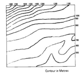
What are contours?
Contours are imaginary lines joining places having the same elevation above mean sea level. In other words, these are imaginary lines joining all the points of equal elevation or altitude above mean sea level. They are also called "level lines". A map showing the landform of an area by contours is called a contour map. The method of showing relief features through contour is very useful and versatile. The contour lines on a map provide a useful insight into the topography of an area.
Topper's Solved these Questions
- TOPOGRAPHICAL MAPSBOOK - FULL MARKSCHAPTER - TOPOGRAPHICAL MAPSEXERCISE - EXERCISE (Exercise A)
4 Videos
- TOPOGRAPHICAL MAPSBOOK - FULL MARKSCHAPTER - TOPOGRAPHICAL MAPSEXERCISE - EXERCISE (Exercise B)
8 Videos
- TOPOGRAPHICAL MAPSBOOK - FULL MARKSCHAPTER - TOPOGRAPHICAL MAPSEXERCISE - ADDITIONAL QUESTIONS WITH ANSWERS (Viva Questions)
5 Videos
- STRUCTURE AND PHYSIOGRAPHYBOOK - FULL MARKSCHAPTER - STRUCTURE AND PHYSIOGRAPHYEXERCISE - Additional Questions With Answers (VI. Map/Diagram Based Questions)
6 Videos
- WATER IN THE ATMOSPHEREBOOK - FULL MARKSCHAPTER - WATER IN THE ATMOSPHEREEXERCISE - (ADDITIONAL QUESTIONS WITH ANSWERS ) V HOTS Questions
2 Videos
Similar Questions
What are the features of contours?
View SolutionIdentify the landform marked by contours in 9782.
View SolutionConsider the contour plot given below:

The above contours of an area indicate several relief features. Which one among the following relief features is not depicted here?
View SolutionName the type of plan which provides the broad contours of an organisations's business.
View SolutionWhat are zeolites ? What is their utility ?
View SolutionWhat are annuli? What is their function.
View SolutionWhat are tears, and what are their functions?
View SolutionWhat are mesosomes ? What is their function?
View SolutionWhat does the spacing of contours indicate?
View SolutionStudy the Topographical Sheet Number 45D/7 and answer the following questions:
Eastings : 41 to 47, Northings : 76 to 85
What is the contour interval of the given toposheet?
View Solution
