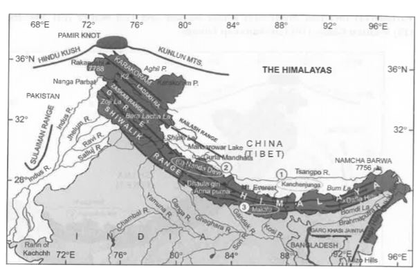
On the given map of Himalaya range, show the following:
(i) Kanchenjunga (ii) Nanda Devi (iii) Makalu
Topper's Solved these Questions
- PHYSICAL FEATURES OF INDIABOOK - VK GLOBAL PUBLICATIONCHAPTER - PHYSICAL FEATURES OF INDIAEXERCISE - NCERT Corner ( Answer to NCERT Questions )(Choose the right answer from the four alternatives )
4 Videos
- PHYSICAL FEATURES OF INDIABOOK - VK GLOBAL PUBLICATIONCHAPTER - PHYSICAL FEATURES OF INDIAEXERCISE - NCERT Corner ( Answer to NCERT Questions )(Answer the following questions briefly )
4 Videos
- PHYSICAL FEATURES OF INDIABOOK - VK GLOBAL PUBLICATIONCHAPTER - PHYSICAL FEATURES OF INDIAEXERCISE - HOTS ( Higher Order Thinking Skills )
9 Videos
- NATURAL VEGETATION AND WILDLIFE BOOK - VK GLOBAL PUBLICATIONCHAPTER - NATURAL VEGETATION AND WILDLIFE EXERCISE - NCERT Corner (Source-based Question)
3 Videos
- POPULATIONBOOK - VK GLOBAL PUBLICATIONCHAPTER - POPULATIONEXERCISE - NCERT CORNER (Answer to NCERT Questions)
11 Videos
Similar Questions
On the given map of West Asia, mark and locate the following cities:
(i) Mecca (ii) Medina (iii) Damascus
(iv) Antioch (v) Edessa (vi) Armenia
(vii) Bukhara (viii) Samarqand
View SolutionOn an outline map of India, mark and label the following:
(i) Nanda devi (ii) Panchmarhi (iii) Manas
(v) Similipal (iv) Nilgiri (vi) Bay of Mannar (vii) Great Nicobar (viii) Nokrek
(ix) Sunderbans (x) Achanakmar - Amarkantak.
View SolutionOn the given outline map of India, mark and label the following rivers:
(i) Krishna
(ii) Brahmaputra
(iii) Satluj
View SolutionOn the outline map of Western Himalayas mark and indicate the following features:
(i) K2 (ii) Nanga Parbat (iii) Kailash Range (iv) Pamir Knot (v) Shiwalik Range (vi) Zojila Pass
View SolutionOn the map of Australia mark and locate the following:
(i) Perth (ii) Sydney
(iii) Adelaide (iv) Darwin
(v) Melbourne (vi) Canberra
View SolutionOn the given outline map of India show the following:
(1) The Karakoram, (2) The Zaskar, (3) The Patkai Bum, (4) The Jaintia, (5) The Vindhya range, (6) The Aravalli, (7) The Cardamom hills, (8) K2, (9) Kanchenjunga, (10) Nanga Parbat (11) the Anai Mudi, (12) Chota Nagpur and (13) Malwa (14) The Indian Desert, (15) Western Ghats, (16) Lakshadweep Islands.
View SolutionOn the given map of Britain, mark and locate the following iron and coal manufacturing areas.
(i) Leeds
(ii) Shefficld
(iii) Liverpool
(iv) Bristol
(v) Swansea
View SolutionOn the given outline map of India, identify and mark the following:
(i) Most populations state.
(ii) State having highest density of population.
(iii) State having lowest density of population.
View SolutionOn the given outline political map of India, locate the following:
(i) All the 28 states
(ii) All the 8 Union Territories
(iii) Any 2 neighbouring countries.
View SolutionOn the given outline map of India, label the following.
(i) Areas of Evergreen Forests.
(ii) Area of Dry Deciduous Forests.
(iii) Two National Parks each in Northern, Southern, Eastern and Western parts of the country.
View Solution

