The distance between City A and City B on a map is given as 6 cm. If the scale represents 1 cm = 200 km, then find the actual distance between City A and City B
The correct Answer is:200 km
To find the actual distance between City A and City B based on the given map distance and scale, we can follow these steps:
1. Identify the Map Distance:
The distance between City A and City B on the map is given as 6 cm.
2. Understand the Scale:
The scale provided is 1 cm = 200 km. This means that for every 1 cm on the map, the actual distance is 200 km.
3. Calculate the Actual Distance:
To find the actual distance, we need to multiply the map distance by the scale factor.
Actual Distance=Map Distance×Scale Factor
Substituting the values:
Actual Distance=6cm×200km/cm
4. Perform the Multiplication:
Actual Distance=1200km
5. State the Final Answer:
Therefore, the actual distance between City A and City B is 1200 km.
Final Answer:
The actual distance between City A and City B is 1200 km.
---
The distance between City A and City B on the map is given as 6 cm.
The scale provided is 1 cm = 200 km. This means that for every 1 cm on the map, the actual distance is 200 km.
To find the actual distance, we need to multiply the map distance by the scale factor.
Actual Distance=Map Distance×Scale Factor
Substituting the values:
Actual Distance=6cm×200km/cm
Actual Distance=1200km
Therefore, the actual distance between City A and City B is 1200 km.
The actual distance between City A and City B is 1200 km.
Topper's Solved these Questions
- BOOK - NCERT EXEMPLARCHAPTER - VISUALISING SOLID SHAPES EXERCISE - TRY THIS5videos
VISUALISING SOLID SHAPES
- BOOK - NCERT EXEMPLARCHAPTER - VISUALISING SOLID SHAPES EXERCISE - THINK AND DISCUSS18videos
VISUALISING SOLID SHAPES
- BOOK - NCERT EXEMPLARCHAPTER - UNDERSTANDING QUADRILATERALS AND PRACTICAL GEOMETRYEXERCISE - THINK AND DISCUSS2videos
UNDERSTANDING QUADRILATERALS AND PRACTICAL GEOMETRY
Similar Questions
The distance between school and house of a girl is given by 5 cm in a picture, using the scale 1 cm : 5 km. Find the actual distance between the two places?
View SolutionThe scale of a map is given as 1:30000000. Two cities are 4 cm apart on the map. Find the actual distance between them.
View Solution
Knowledge Check
- Question 1 - Select One
The distance between two cities A ad B in a map is 7.5 cm. the scale taken for drawing this map is 1cm=1,50,000m. The actual distance between A and B is____km.
A1125000B20000C200D1125 - Question 2 - Select One
The distance between two cities A ad B in a map is 7.5 cm. the scale taken for drawing this map is 1cm=1,50,000m. The actual distance between A and B is____km.
A1125000B20000C200D1125 - Question 3 - Select One
The distance between school and house of a girl is given by 5 cm in a picture, using the scale 1 cm:5 km. Find the actual distance between the two places?
A5 kmB20 kmC10 kmD25 km
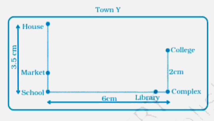
Use a ruler to measure the distance in cm between the places joined by dotted lines. If the map has been drawn using the scale 1 cm :10 km, find the actual distances between
(1) School and Library
(2) College and Complex
(3) House and School
 View Solution
Read the following problem given in a textbook for Class VII. "A map is given with a scale of 2 cm = 1000 km. What is the actual distance between two places (in km), if the distance on the map is 2.5 cm?" This problem is
View SolutionRead the following problem given in a textbook for class VII:
"A map is given with a scale of 2 cm = 1000 km. What is the actual distance between two places, in kms, if the distance on the map is 2.5 cm?View SolutionRead the following problem given in a textbook for Class VII.
"A map is given with a scale of 2 cm = 1000 km. What is the actual distance between two places (in km), if the distance on the map is 2.5 cm?" This problem is:View SolutionThe scale of a map is 1:3×10⁷. Two cities are 5 cm apart on the map. Find the actual distance between them in kilometers.
View Solution

